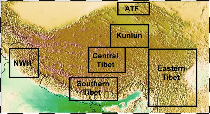
| Southern Tibet | Central Tibet | Northern Tibet | Altyn Tagh Fault | Northwest Himalaya | Eastern Tibet - Longmenshan |

Since 1995 I have worked in Tibet with the INDEPTH project. We have collected an extensive set of MT data from South of the Himalaya to the Qaidam Basin. These data are being used to study the tectonic processes at work in an active continent-continent collision. In addition I have collaborated with other Chinese and Indian researhers using MT data to study this region.

Southern Tibet
Initial fieldwork took place in Southern Tibet in collaboration with the Chinese University of Geoscience.Results summarized by Chen et al., (1996) and showed that high conductivities were widespread in the Tibetan crust.
Addition MT profiles recorded in Southern Tibet to investigate east-west variations in crustal structure. Unsworth et al., (2005) showed that the structures imaged in 1995 are representative of the entire orogen. Also showed that the resistivity values are consistent with geodynamic models that propose crustal flow.

Central Tibet
The INDEPTH 500-line was recorded in Central Tibet in 1998. Results summarized by Wei et al., (2001) and Solon et al., (2005)

Kunlun Shan
The INDEPTH 600-line recorded across the Kunlun Fault and Qaidam basin. This study showed that the mid-crustal conductor terminated at the Kunlun Fault. See Unsworth et al., (2004) for details.

Altyn Tagh Fault
Commercial MT data were used by Bedrosian et al., (2001) to study the structure of this major fault that forms the Northern margin of the Tibet Plateau.

Northwest Himalaya
Arora et al., (2007) describe long-period MT data collected during the HIMPROBE project.

Eastern Tibet and Longmenshan
Bai et al., (2010) describe long-period MT data collected during the EHS3D project show the pattern of crustal deformation around the Eastern Himalayan Syntaxis.Zhao et al., (2012) describe the first detailed MT study of epicentral region of the 2008 Wenchuan earthquake.

Photographs of Tibet
- Fieldwork
- People and culture
- More of my Tibetan photos on PBASE

Back to the Tectonics research page
