
You are visitor number
You can see the last 20 users
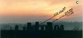
An accurate Summer Solstice Sun Rise line in 4000 BP ran from a tump in Oval-Twin-Disk-Barrow 10, 300 m SW of the Sarsen Circle, through a narrow window framed by the Great Trilithon Sarsens 55, 56 and 156 on the sides and top, and Sarsen Circle lintel 116 on the bottom. The treeless horizon 3.1 km away, if observed from about 0.7 m above the ground, would have nearly coincided with the top of lintel 116. The corresponding Sun Set line ran from the SE Bank of Stonehenge Ditch, to between Sarsens 8 and 53, above and parallel to the length of the Altar Stone, through a narrow gap between Bluestone 69 and Sarsen 58, to Cursus Bowl-Barrow 49 on a ridge 930 m from the Sarsen Circle centre, and to the Lesser Cursus on the treeless horizon 2.1 km away. The Summer Solstice Sun Set Bowl-Barrow 49 is the same distance from the Sarsen Circle as is the Winter Solstice Sun Set Bell-Barrow 15. The Summer and Winter Solstice Sun Rise lines do not cross burial mounds, whereas the Set lines do. The Summer Solstice Sun Rise and Set lines cut symmetrically across The (Greater) Cursus, although The Cursus direction is 6° off from due E-W. Other symmetries of the site are noted.
Stonehenge probably means suspended (hanging) stones, not a gallows. In the delightful little book by Florence Antrobus (1902) she quoted an Anglo-Norman poet, Wace:
Stanhengues ont nom en Englois
Pierres pendues en François.
The pierres pendues are the lintels; the wonderment was how they were put up there. The thirty-three lintels weighed six to seventeen tonnes each and were perched four to seven metres above the ground. To gauge the modern bewilderment about this type of ancient accomplishment, consider that on 25 August 1999 an experienced plains-archaeologist asked with disbelief how a two-tonne rock could have been moved onto the side of a hill at the Sun Temple near Majorville, as we had said, to put it into a Solstice line.
Antrobus mentioned or displayed two significant facts that have been ignored by more recent authors: (i) as one proceeds down the Avenue from the Sun (Heel) Stone toward the elbow, at about 1500 feet distance the descent becomes more rapid; (ii) the Altar Stone protrudes appreciably beyond the NW side of the fallen lintel 156. She also offers two interesting speculations: (i) there were 28 lintels on the Sarsen Circle, not 30, two probably being absent between Sarsens 10 and 12; (ii) the word Heel in Heel Stone might derive from Hele, Heol, Geol and Jul, meaning Sun (recall the Greek helios; the Greeks do not pronounce this h any more than the English do). In fact Jul and Yule derive from old Norse and Anglo-Saxon words that mean Winter Solstice (Funk & Wagnalls).
We mention Antrobus' 1902 book, still refreshing in 1999, because recent publications about Stonehenge display fatigue: "we know all we want to know." For some reason current archaeoastronomers believe that the people who constructed the intricate, massive, refined Stonehenge couldn't measure a Sun Rise or Set direction to closer than 2 or 2 1/2 degrees. One archaeoastronomer also wondered in a recent article whether the people who constructed Stonehenge could count as high as "more than 180" and divide it by two (Ruggles 1997)!
A new technique of accurate observational archaeoastronomy (Freeman & Freeman 1999a) has dispelled the tiredness and offered a different view of Stonehenge (Freeman & Freeman 1999b). While Priests might have worked mainly within the Sarsen Circle, it seems that Skywatchers worked mainly outside it.
If Stonehenge orientations mainly concern the Sun, why do the short sides of the Rectangle of Station Stones point roughly to the semiannual Solstitial Sun Rise and Set, while the 2.4 times longer sides point roughly to much rarer Solstitial Moon Rise and Set extremes that occur only at 19-year intervals? The angles at the corners of the Rectangle are roughly Right Angles, but the semiannual swing of the Sun Rise and Set along the horizon covers only 80°, ten degrees short of a Right Angle. The Moon Rise and Set lines oscillate slowly back and forth across the Sun lines; once every 19 years the near-Solstice Full Moon Rise and Set reach about 10° beyond the Sun lines at Stonehenge. Thus one obtains the Sacred Right Angle between the Solstitial Sun and Moon Rises and Sets once each 19 years, at the 51° latitude of Stonehenge and of the Sun Temple near Majorville, Alberta (Freeman & Freeman 1990).
Future scholars will no doubt return to the Why of the particular shape of the Station Rectangle, whose Moon sides touch tangentially the outside of the Sarsen Circle at the orifices for passage of light from the Summer Sun Rise and Winter Sun Set (gaps 1-30 and 15-16 for both events). For now we show that the accurate Solstitial Sun lines run from one side to the other across the Circle, and are neither the remote end lines of the Station Rectangle nor lines from points inside the Circle to points outside it.
The Summer Solstice Sun Rise viewed from the centre of the Sarsen Circle in 4000 BP occurred 1.5° to the left of the Heel Stone (Atkinson 1979, 15; Hawkins 1965, plates 17-20; Newham 1972, 9). This error was fifteen times larger than the error of the Solstice Sun Rise and Set lines at the similarly dated Sun Temple near Majorville, Alberta (Freeman & Freeman 1990). The Heel Stone was therefore probably not a Summer Solstice foresight. It was, however, a possible viewing position for the Winter Solstice Sun Set: the line from the Heel Stone extended between Sarsen 95 and its probable mate, to between Sarsens 1 and 30, 55 and 56, 15 and 16, and the Sun disappeared where the dome met the flare of Bell-Barrow 15, into a treeless horizon (Freeman & Freeman 1999b). The line was 1020 m long and was constrained to about 0.2° by the gap between Sarsens 55 and 56 in the Great Trilithon.
During our work at Stonehenge in the Decembers of 1995 and 1997 we picked a probable viewing position for the Summer Solstice Sun Rise. In 4000 BP the viewing line would also have been narrowly constrained by Sarsens 55 and 56. We returned in June 1999 to verify the line.
A line for the observation of the Winter Solstice Sun Rise from the NW Bank was constrained by the narrow gap between Trilithon Sarsen 58 and Bluestone 69 (Freeman & Freeman 1999b), and it passed along the length of the Altar Stone, out to a distant, treeless horizon. A large notch that had been carved into the SW side of Sarsen 58, to widen the angle of view, made it virtually certain that a Summer Solstice Sun Set line would run from the SE Bank back along the length of the Altar Stone, and out between Bluestone 69 and Sarsen 58 to a distant, treeless horizon. Was anything manmade at the Summer Set place, as there was for the Winter Set?
In the societies that built Stonehenge and the Sun Temple near Majorville, the jobs of Skywatcher and Priest were probably not done by the same person. The Skywatcher probably made quantitative measurements and drew conclusions, as technologists and scientists do today. Priests probably ministered to people, and provided rituals and ceremonies at calendric points determined by the Skywatchers, then as now.
The camera, lenses, tripod and technique were the same as those reported earlier (Freeman & Freeman 1999a,b).
The acuity of GRF's eyes is greater than that of the photoprints in this study, and was even greater 45 years ago. Visual color differentiation is also greater than that recorded on the photoprints. A trained Skywatcher 4000 years ago could have seen much more detail than shows in our photos. The camera is merely a recording device that is adequate for the present purpose.
During the visit to Stonehenge in December 1995 we determined that Oval-Twin-Disk-Barrow 10 (OTDB-10) is 300 m along the SW extended axis of the Sarsen Circle, and is not in the Winter Solstice Sun Set line of 4000 BP. From near the centre of OTDB-10 the horizon in the Summer Solstice Sun Rise direction would nearly coincide with the top of the Sarsen Circle lintels if the trees were removed from the horizon. The bottom of the Great Trilithon lintel 156 would have been 0.33°, 1.7 m, above where the top of Circle lintel 116 would have appeared from this viewpoint. Lintel 156 is 4.6 m long, and the widths of Sarsens 55 and 56 at 1.7 m from their tops are 2.0 m, which indicates a gap of 0.6 m at that level, and increasing from there up. A 0.6 m gap between Sarsens 55 and 56 at the level of lintel 116 would have an angular width of 0.12° seen from OTDB-10. A possible foresight for the Summer Solstice Rise was therefore the 0.12°-0.18° wide window framed by Sarsens 55, 56, 116 and 156, viewed from OTDB-10, perhaps from one of the two tumps.
The Oval Barrows predate Stonehenge by several centuries (Darvill 1997, Fig. 3).
To assess the reproducibility of our measurements by obtaining two adequately clear Sun Rises and Sets, the visits to England were for three weeks each December, and two weeks in June. One works within the constraints of the weather and of Special Access schedules at Stonehenge.
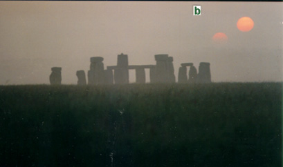
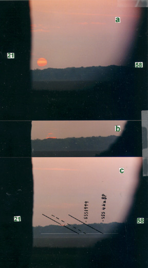
The first adequate Sun Rise was photographed from 9 m SW of the SW edge of the ditch of OTDB-10, to include the ditch and a tump in the photograph (Fig. 1a). Phyl, standing on the tump, is on the extended axis of the Sarsen Circle (Fig. 1b), as is the camera. The axis passes on the right side of Sarsens 16, 56 and 30; the Heel Stone is entirely hidden by Sarsen 1. If one moved 6 m to the left, 1.0° clockwise from Sarsen 1, the middle portion of the Heel (Jul?) Stone would be seen in the gap between Sarsens 56 and 1, and one would be in the Winter Solstice Sun Set line that ends at the NE groin of Bell-Barrow 15 (Freeman and Freeman 1999b).
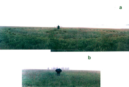
| Figure 1. | Oval-Twin-Disk-Barrow 10 viewed from 9 m SW of the SW edge of its ditch, camera 1.5 m above the ground. The photos of Fig. 2 were also taken from this position. Phyl is standing on the tump from which the photos of Fig. 3 were taken. 12 June, 1999: (a) focal length 35 mm, photos 1 1 8 and 9, time 05h01m; (b) focal length 105 mm, photo 1 1 10, 05h02m. Photos are designated by the date, lens no. 1 or 2, film roll no. (bold face), and negative no. |
Frequent cloud and fog in the early mornings resulted in a clear photograph of the Sarsens one morning, but with clouded Sun, and visible rising Sun the next morning, with foggy Sarsens. However, the tripod position was marked on the ground with a handfull of chalk pebbles, and the tripod was at a reproducible setting with the camera 1.5 m above the ground, so the Sarsens projected to the same positions in the background of trees in the photographs. Figures 2a and b show the hazy Sun; the images are sufficiently clear to measure the positions of the upper limb with respect to the tree tops and the Sarsens. These positions were then marked on a clearer photo of the trees and Sarsens, taken the previous day (Fig. 2c).
|
|
The treeless horizon would have been in a shallow saddle-crest in Durrington CP, 3.1 km away. The tallest trees at this place are pines, estimated to be 21 m high. The position of the horizon in Fig. 2c was drawn at (21 x 57/3100) = 0.39° below the highest tree tops, which corresponds to 5.9 mm below them on the original 101 mm x 152 mm photoprint.
The trajectory of the rising Sun was extrapolated back to the treeless horizon, with the aid of the appropriately scaled, refraction-modified, Rise/Set curve in Fig. 4 of Freeman & Freeman (1999b).
There are 93 days from the Vernal Equinox to the Summer Solstice, so each day represents about 0.97° of motion along the Earth's orbit. The total shift of the Sun Rise or Set point during these 93 days is 39.7° ± 0.2°, so the shift
Dq during n days to or from the Solstice is approximately
| Dq = 39.7° (1 - cos 0.97°n) | (1) |
Thus the Rise on the Solstice 21 June occurred 0.36° to the left of that on 13 June.
The Rise on the Summer Solstice 4000 years ago was a further 0.94° to the left (Table 1). This Rise point in Fig. 2c would be 0.07° to the right of Sarsen 56.
Sarsens 55 and 156 have been sketched on Fig. 2c to show the Summer Solstice Sun Rise point within the window above the Sarsen Circle.
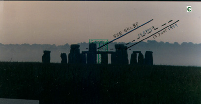
The second adequate Sun Rise was recorded on 17 June (Fig. 3). It was photographed from the tump shown in Fig. 1, with the camera 0.7 m above the ground to match the estimated level of the treeless horizon with the estimated top of Circle lintel 116. The latter, viewed from OTDB-10, would have been slightly higher than the presently visible lintel 101.
|
|
The top of the Sun is visible above the 0.6° thick band of clouds in Fig. 3a. The positions of the Sun tips with respect to the treetops and Sarsens in Fig. 3b were marked on Fig. 3c, and the extrapolations were made as before. The shift from 17 to 21 June was 0.09°, and to 4000 BP was another 0.94°. This Rise point was 0.09° to the right of Sarsen 56. The closeness of agreement with the 0.07° result in Fig. 2 is accidental, in view of the extrapolations involved. However, the estimated uncertainty is less than 0.1°.
If the trees in Figs. 2 and 3 actually project 26m (or 16 m) above the treeless horizon level, instead of the assumed 21 m, in the Summer Solstice Rise line of 4 ka BP, the observation point within OTDB-10 would merely move 1.0 m to the right (or left) to put the first flash of the Solstice Sun in the superb Sarsen window that projected above the Sarsen Circle (Fig. 2c).
The SSR line drawn on Fig. 6 (see later) passes about 20 m, 0.4°, NW of the top of Peter's Mound, a small mound in the SE side of the shallow saddle in Durrington CP (PM in Fig. 6, OS coordinates 14334 43967, Thom et al. 1974). To restore the view of the Summer Solstice Rise horizon from OTDB-10, trees would have to be cleared from a 200 m section of the N side of the E end of The Cursus, from 200 m to 400 m W of the Long Barrow, and from the area within a 75 m radius of Peter's Mound.
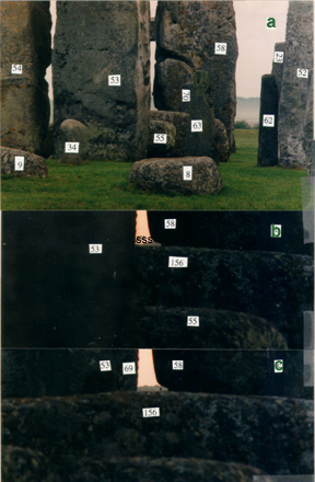
The setting Sun recorded on 12 June 1999 is shown in Fig. 4. It was viewed through the notch in the SW edge of Trilithon Sarsen 58, in line with the Altar Stone. The positions of the upper limb of the Sun in (a) and (b) were marked on (c) to permit extrapolation to the probable treeless horizon of 4 ka BP.
|
|
The treeless horizon viewed through the notch in Sarsen 58 would have been at the Lesser Cursus, 2050 m away. It would have been at an observing altitude 0.20° above the intervening ridge 920 m away, on which The (Greater) Cursus tumuli were built. The 0.20° corresponds to 3.1 mm above the ridge on the 101 mm x 152 mm photoprint, and is marked on Fig. 4c. [The height of the base of Sarsen 58 is 102.6 m above MSL (Thom et al. 1974) so the notch is 104 m MSL. This is consistent with the contours in Ordnance Survey Explorer 130 (1998). The heights of the Lesser Cursus and the intervening ridge are estimated to be 118 m and 107 m MSL, respectively. The respective observing altitudes from the notch are 0.39° and 0.19°.]
The trajectory of the setting Sun in Fig. 4c was projected to the level of the treeless horizon, using the scaled Rise/Set curve from Fig. 4 of Freeman & Freeman (1999b), as before.
The Sun Set on 21 June occurred 0.46° to the right of that on 12 June (eqn 1). Summer Solstice Set around 4000 BP occurred a further 0.94° to the right (Table 1). These Set points are marked on Fig. 4c.
The setting Sun on 15 June is recorded and similarly marked in Fig. 5. The Solstice Set was 0.20° to the right of that on 15 June. The Solstice Set positions estimated in Fig. 5 are 0.04° to the right of those estimated in Fig. 4.
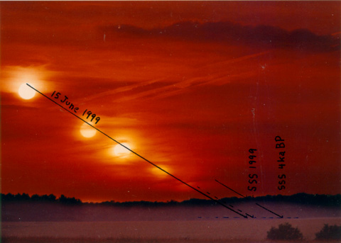
| Figure 5. | Setting Sun viewed from 2.4 m NW of the notch in Sarsen 58, 1.5 m above the ground. Focal length 120 mm; photo enlarged 1.70x more than the others in this article. 15 June, 1999, 2 4 2: 20h43m25s, 20h53m25s, 20h59m00s, 21h05m05s, 21h09m00s. The dashed horizontal line is the estimated treeless horizon (see text). |
By way of comparison with the 21 m estimated height of the tallest pines on the Summer Solstice Sun Rise horizon, the estimated height of the tallest pines just to the left of the Summer Set line is 20 ± 2 m. [Their sighting altitude above the nearer ridge is 0.77°, or 13 mrad, their distance from Sarsen 58 is about 1.6 km, and their bases are at about the sighting altitude of the nearer ridge, estimated from Fig. 4a and Ordance Survey Explorer 130; 0.013 x 1600 = 21 m.]
The Summer Solstice Sun Set line for 4000 BP crosses the nearer ridge (Cursus Tumili ridge) at what would have been the NE base of the dome of Bowl-Barrow 49 (Amesbury 49; Victoria History 1957, 151), which has since been greatly diminished by plowing or other means (Fig. 6). Bowl-Barrow 49 is 19 paces (17 m?) in diameter and only 0.6 m high (Victoria History 1957); it is much smaller than the Winter Solstice Sun Set Bell-Barrow 15. Barrow 49 is not visible in our photographs from the Sarsen Circle; it was probably initially more than 1 m high. It would have had to be 3 m high to touch the treeless horizon.
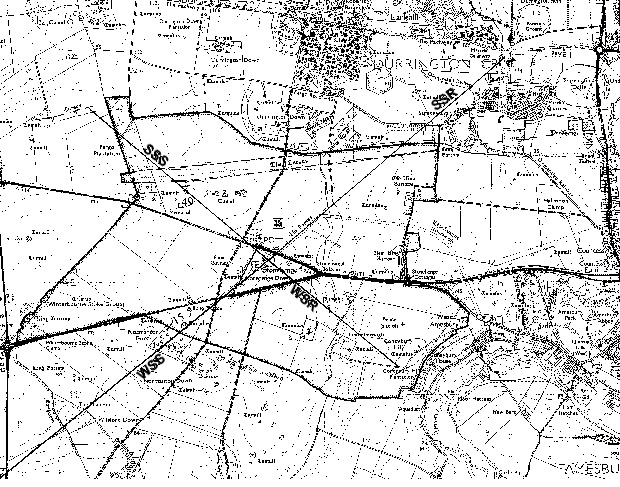
| Figure 6. | Map of the Stonehenge area, showing the 4000 BP Summer Solstice Sun Rise (SSR) and Set (SSS), and Winter Solstice Sun Rise (WSR) and Set (WSS) lines that traverse the Sarsen Circle. The background map is from Ordance Survey Explorer 130 (1998), with permission of The Controller of Her Majesty's Stationery Office, ©Crown copyright NC/99/123. PM = Peter's Mound (see text). A copy of the original may be obtained from the author. |
The Summer Set line joins the horizon within an Oval Enclosure in the Eastern portion of the Lesser Cursus. The 14 m x 16 m Oval was found during a recent magnetometer survey of the area (David and Payne 1997, Fig. 8). The Oval is not symmetrically placed within the Lesser Cursus, so was probably made before or after the period of use of the latter. The space occupied by the Oval, expressed as fractions of the 52 m width and 400 m length of the Lesser Cursus, is 0.147 to 0.417 from the N ditch, 0.145 - 0.185 from the open E end. The Sun Set line in Figure 6 crosses the Lesser Cursus within this zone, for example through the point 0.16 of the width from the N ditch, 0.156 ± 0.009 of the length from the open E end. An uncertainty of 0.1° in the Sun Set direction corresponds to an uncertainty of 0.009 in the fractional length of the Lesser Cursus. The Oval could have marked the Summer Solstice Sun Set in Phase 1, in 5.0 ka BP.
The Summer Set location in 4000 BP is visible from the SE Bank of Stonehenge Ditch, through gaps between Sarsens 8 (standing) and 53, and Bluestone 69 and Sarsen 58 (Fig. 7). The sighting line also passes between the Circle Sarsens 8 and 9, and 21 and 22 on the far side; these gaps are wide and do not constrain the angle of view. The NE edge of Bluestone 69 is visible beyond the NE edge of Sarsen 53 in photos 7a and b; material has been removed from the edge of 69 at the sighting level, to widen the angle of view slightly. The eye level for sighting the treeless horizon in the notch of Sarsen 58 is about 1.6 m above the present Bank, a few cm higher than the camera for Fig. 7a.
|
|
Viewed from the Summer Sun Set point on the SE Bank, the angular width of the gap between Bluestone 69 and the widest part of the notch in Sarsen 58 is 0.23° (Fig. 7), and the narrowest part of the gap is 0.08°.
Manmade Structures in the Winter and Summer Solstice Sun Set Lines
The Winter Solstice Sun, observed from the Heel Stone, sank into the 4.3 km distant, treeless horizon about 0.1° above the SE junction of the dome and flare of Bell-Barrow 15. The top of the Barrow penetrated the horizon, making a slight angle roughly 0.3° short (NW) of the turn around point of the Sun Set.
The Summer Solstice Sun, observed from the SE Bank of Stonehenge Ditch, sank into the distant, treeless horizon at the Lesser Cursus, 0.2° above the NE base of the dome of Bowl-Barrow 49 (Fig. 6). Excavation of this Barrow has not been recorded (Royal Commission 1979, Map 2), but it has been nearly destroyed by plowing or other means.
Ring-Ditch Amesbury 114 is immediately on the S side of Bowl-Barrow 49. The Ring-Ditch 114 and Bowl-Barrows 48a and 115 (Royal Commission 1979, Map 2) form a line in the Summer Set direction that runs about 20 m S of the SSS line drawn on Fig. 6. We mention this simply because all three of the structures have been nearly destroyed by plowing or other means. None are visible in our photographs, but their remains are visible in aerial photographs (Royal Commission 1979). One wonders whether they predate the Sarsen Circle, and why these were destroyed and not others.
There is a remarkable symmetry in the arrangement of the Summer and Winter Solstice Sun Set Barrows 49 and 15 about the Sarsen Circle. The centre of 49 is 930 m from the centre of the Sarsen Circle, nearly the same as the 938 m of the centre of 15 from the Circle centre (Fig. 6). Furthermore, 49 is 1.2°, nearly due N, 1170 m from 15. This N-S line emphasizes the relationship between the Cardinal Directions and the seasonal positions of the Sun. Three wooden posts extended from the interment to the surface of 15; were there similar posts in 49?
The Summer and Winter Solstice Sun Rise lines do not cross burial mounds. The Set lines do. The Summer Rise line begins at an Oval Barrow, while the Summer Set line ends at an "Oval Enclosure".
Restoration of the 4000 BP observation lines would require removal of trees that obscure the distant horizon for observers near the Sarsen Circle. Trees would have to be removed from Fargo Plantation, portions of the N side of The Cursus and the SE shoulder of Lark Hill, and Normanton Gorse.
The Summer Solstice Sun Rise and Set lines cut symmetrically across opposite ends of The Cursus. If the Long Barrow is the Eastern end of The Cursus, which is otherwise outlined by a ditch, The Cursus is 2800 m long. The Sun Rise and Set lines in 4000 BP cut the Southern ditch 480 m from the ends, and cut the Northern ditch 325 m from the ends.
The Cursus does not run due E-W, but about 6° off (84° - 264°, Fig. 6). The Southern ditch bends and runs due W from near the place where the Summer Set line cuts it. The Eastern end of the Northern ditch is now indistinct, but it runs nearly due E from the place where the Summer Rise line cuts it (Fig. 6).
What is the reason for this connection between the Summer Solstice Sun Rise and Set directions from Stonehenge and the shape of The Cursus?
The long straight portion of the Southern ditch runs 163° - 83° and extrapolates along 83° to the Southern edge of Woodhenge bank, 1350 m away (Ordnance Survey Explorer 130). The long straight portion of the Northern ditch runs 164° - 84° and extrapolates to 70% along the S-N diameter of Woodhenge bank, about 24 m S of the N edge. Woodhenge contained six concentric ovals of posts, surrounded by a nearly circular ditch and outer bank 80 m in diameter. The central oval was 13 m NE-SW and 9 m NW-SE; it contained a grave that was roughly perpendicular to the long axis (Richards 1991, 96). A slight ridge hides Woodhenge from The Cursus, so why was Woodhenge placed on an extrapolation of The Cursus Southern ditch? A horizon marker, the "Cuckoo Stone", showed the direction from each end (Darvill 1997, Fig. 7). Woodhenge is on the Eastern edge of the local high land, which then drops 25 m to the Avon, which runs N-S at that place. The location of Woodhenge might have to do with observation of Sun Rises throughout the year.
The Summer Solstice Sun Rise and Set lines for 4 ka BP cross above the middle of the Altar Stone, as do the 4 ka BP Winter Solstice lines. The Altar Stone at that time must have been in essentially its present orientation.
Atkinson (1979, 212) stated that the SE end of the Altar Stone had "been dressed to an oblique bevelled outline, very much like the bases of some of the sarsens." He also stated (56) that "The Altar Stone is not symmetrical to the axis, nor does it lie at right-angles to its line... ." It is therefore commonly assumed that the Altar Stone formerly stood upright on the Circle axis, and has fallen on top of its own stone-hole (Atkinson 1979, 56; Richards 1991, 61; Cleal et al. 1995, 231; North 1996, 426). However, we have not been able to find Atkinson's drawing of the oblique bevelled end of the Altar Stone. Cleal et al. (1995, 216 and Plan 2) drew the large NW piece of the Altar Stone bevelled on both ends, and the smaller SE piece roughly square. They did not show the 0.3 m of the large piece that protrudes NW of lintel 156, and drew the overall length 4.3 m instead of 4.9 m. North (1996, 425) drew the bevel on the SE end of the SE fragment, and the overall length 4.3 m. We confirmed Atkinson's measured length of 4.9 m, but not the bevelled SE end. The bevel of the piece under Sarsen 55b might be the result of the break.
The Altar Stone is not at right-angles, 90°, to Stonehenge axis, but it makes angles of about 100° and 80° with it to accommodate the angle between Solstice Sun Rises and Sets, and the semiannual swing of the Rise and Set points. In 4 ka BP the angle between Solstice Rise and Set at Stonehenge was 100.7° centered on S in Winter, and 98.3° centered on N in Summer.
The Summer Solstice Sun Rise line from OTDB-10 in 4000 BP passed directly above the length of the Avenue from Stonehenge Ditch to the bend in Stonehenge Bottom (Fig. 6). The Avenue from the bend to the Heel Stone slopes gently upwards, so from an appropriate place in this portion of the Avenue the setting Sun at the Winter Solstice could be seen entering the SE side of the Sarsen Circle; the position of apparent entry would be where the sighting line was tangent to the Circle, between Sarsens 8 and 9. If the Bank near Aubrey Holes 3 and 4 were 103 m MSL in 4 ka BP (it is now 102 m MSL, Thom et al. 1974), and if the observation were made from 1.5 m above ground, the sighting position could have been in mid Avenue about 470 m from the Bank, and about 90 m from the bend. The observational altitude would be 1.4° to the Bank, and the Summer Set azimuth would be 228.2°, which would run tangent to the Circle.
In the Sun Temple near Majorville, Alberta, there is an upward-sloping Winter Solstice Sun Set line that is the exact opposite of a Summer Solstice Sun Rise line, and the setting Winter Sun appears to enter a Rock on the horizon (Freeman & Freeman, to be published). This led us to consider Stonehenge and the Avenue in the same regard.
The Great Trilithon is not visible from the bend in the Avenue, because the initial slope is too great, unless the viewer's eyes are more than 1.8 m above the ground. As one walks from the bend toward the Circle, first the top of the Great Trilithon, then the tops of the Heel Stone and Sarsen Circle come into view, then more of the structure. It would make a dramatic procession.
We belatedly came upon "The Stones of Stonehenge", by E.H. Stone (1924). Our work supports and refines several of his conclusions, which seem to have been opposed for a while:
Acknowledgments
We thank Stonehenge personnel for special access to the site and for their interest in the project. We are grateful to Dr. and Mrs. R. William Hummel, Mr. and Mrs. Robert Clapp, and Dr. and Mrs. Derek A. Dominey for their hospitality.
Antrobus, Florence C.M. 1902. A Sentimental and Practical Guide to
Amesbury and Stonehenge. 2nd edn. Amesbury, Wilts: Estate Office.
Atkinson, R.J.C. 1979. Stonehenge. 2nd edn. Harmondsworth: Penguin.
Reprinted 1986.
Cleal, R.M.J., Walker, K.E. & Montague, R. 1995. Stonehenge in
its landscape. London: English Heritage.
Darvill, T. 1997. Ever Increasing Circles: The Sacred Geographies of
Stonehenge and its Landscape. Proceedings of the British Academy,
92, 167-202.
David, A. & Payne, A. 1997. Geophysical Surveys within the Stonehenge
Landscape. Proceedings of the British Academy, 92, 73-113.
Freeman, G.R. & Freeman, P.J. 1990. Majorville Medicine Wheel Site:
Distant outliers and accurate Solstice alignments. 23rd Chacmool Conference,
Calgary, Canada, Nov.
Freeman, G.R. & Freeman, P.J. 1999a. Observational Archaeoastronomy
Technique: Variation in estimated positions of Sun Rise and Set due to
atmospheric conditions. Journal of Field Archaeology, (submitted).
Freeman, G.R. & Freeman, P.J. 1999b. Observational Archaeoastronomy
at Stonehenge: Winter Solstice Sun Rise and Set lines accurate to 0.2°
in 4000 BP. Journal of Field Archaeology, (submitted).
Funk & Wagnalls. 1967. Standard Reference Encyclopedia, vol.
25. New York: Standard Reference Works Publishing.
Hawkins, G.S. 1965. Stonehenge Decoded. Garden City, N.Y.: Doubleday.
Newham, C.A. 1972. Astronomical Significance of Stonehenge. Leeds:
Blackburn.
North, J.D. 1996. Stonehenge: Neolithic Man and the Cosmos. London:
Harper Collins.
Ordnance Survey, 1998, Explorer 130, Salisbury and Stonehenge,
Southampton, England. Scale 1:25,000; contour interval 5 m.
Richards, J. 1991. Stonehenge. London: Batsford/English Heritage.
Royal Commission on Historical Monuments (England). 1979. Stonehenge
and its Environs: Monuments and land use. Lord Adeane, Chairman. Edinburgh:
University Press.
Ruggles, C. 1997. Astronomy and Stonehenge. Proceedings of the British
Academy, 92, 203-229.
Stone, E.H. 1924. The Stones of Stonehenge. London: Robert Scott.
Thom, A., Thom, A.S. & Thom, A.S. 1974. Stonehenge. Journal of
the History of Astronomy, 5, 71-90.
Victoria History of the Counties of England. 1957. A History of Wiltshire,
I, part 1; 1972, part 2. London: Oxford University Press.
Table 1.Geographical altitudes h of sight lines, and true altitudes hs of the Sun's center for Summer Solstice Sun Rise and Set seen from Stonehenge, with Rise and Set directions qs in AD 1995 and 4 ka BP.a
|
SSR |
SSS | ||||||
|
mrad |
deg |
mrad |
deg | ||||
|
hb |
8.5 |
0.49 |
6.8 |
0.39 | |||
|
air refractionc |
8.57 |
0.491 |
8.92 |
0.511 | |||
|
hsd |
-4.7 |
-0.27 |
-6.8 |
-0.39 | |||
|
876 |
50.18 |
5411 |
310.02 | |||
|
859 |
49.24 |
5427 |
310.96 | |||
|
857 |
49.11 |
|||||
aRecorded to two or three decimal places when necessary to avoid round-off errors in the calculations. 1 radian = 180°/ = 57.296°.
bSSR from 0.7 m above a tump in OTDB-10 to the treeless horizon 3060 m away, at 131 m MSL. SSS from the notch in Sarsen 58, at 104 m MSL, to the treeless horizon 2050 m away, at 118 m MSL. Estimated from Ordance Survey Explorer 130 (1998), contour map, and Fig. 6 of Thom et al. (1974).
cFrom Figure 4 of Freeman & Freeman (1999b).
dhs = h - Sun's radius - refraction.
eAzimuth for the first or last flash, calculated from eqn (7) or (8) in Freeman & Freeman (1999b), but with + sin
e instead of - sin e. 1999: e = 0.4091 rad = 23.44°. 4.0 ka BP: e = 0.4176 rad = 23.93°. 4.7 ka BP: e = 0.4188 rad = 24.00°.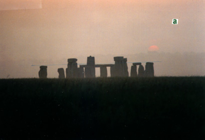