Alberta's WaterIntroductionPublications Climate Change Industrial Impacts Agricultural Impacts Urban Impacts Biodiversity Loss Definitions Links Site Map |
 |
|
 Lost Creeks and Wetlands of Edmonton
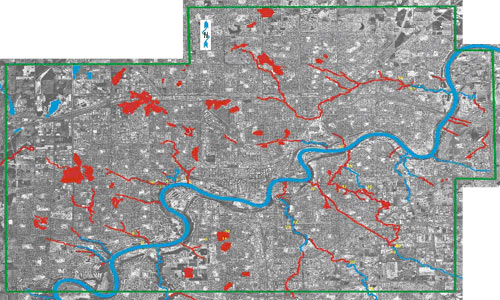 |
| Lost Creeks and Wetlands of Edmonton, Dec 5th, 2001. Blue lines denote existing surface water; red lines indicate lost water, and the green line is the study area boundary. Background is 2001 air photo mosaic, courtesy City of Edmonton. |
Results
The analysis showed that many creeks and wetlands have disappeared as the city of Edmonton has grown. Research at the Edmonton Archives and readings of historical books highlighted the cultural connections that early Edmonton residents had with these water bodies, notably McKernan's Lake, which was once a popular picnic and skating spot. Areas with significant impacts include Fulton Creek, Groat and MacKinnon Ravines, and Second Rat Creek (a major tributary of Kennedale Creek), and marsh areas in industrial developments on the city's outskirts. Many of the creeks and ravines were lost in the 1960's to road and bridge construction. Several marshes and wetlands had already been drained by 1924, largely for agricultural purposes. Current city expansion of industrial areas is encroaching on remaining marshy areas.


