Introduction
Publications
Climate Change
Industrial Impacts
Agricultural Impacts
Urban Impacts
Biodiversity Loss
Definitions
Links
Site Map
|
 |
 Muriel Lake Muriel Lake
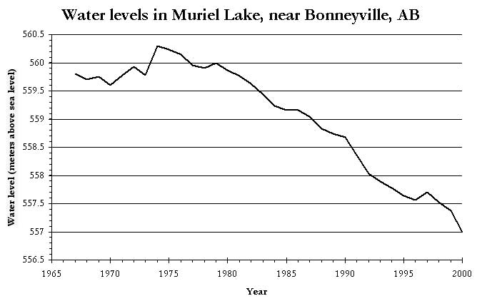
The water level in Muriel lake, located just south of Bonnyville, Alberta, has fallen more than 3 metres since the 1970s. This amounts to perhaps a 50 to 60% loss in the volume of water. The Muriel Lake Basin Management Society was formed in 1999 in response to these severe losses of water.
In 2002, Dr. Bill Donahue, with the support of Dr. Dave Schindler, the Gordon Foundation, the Natural Sciences and Engineering Council of Canada, and ERSC, began a study to determine the local and regional water budgets. Drs. Bill Donahue and Alex Wolfe also began a study of the history of water quality, biology, and climate change in Muriel Lake.
Muriel Lake is located 13 km south of Bonnyville, about 225 km northeast of Edmonton. The lake had an origial area of 63 square kilometres and a mean depth of 5.1 metres. The catchment area is 369 square kilometres, and there is currently no out-flow from the lake.
 Current Concerns Current Concerns
- Water levels fell more than 3 metres from 1975 to today
- Salinity has increased, and the lake is classified as slightly saline
- Concentration of dissolved solids and major ions have increased
- Low oxygen levels have been recorded under winter ice in recent years

Maps
Links
Return to Main Climate Page
|
 |


